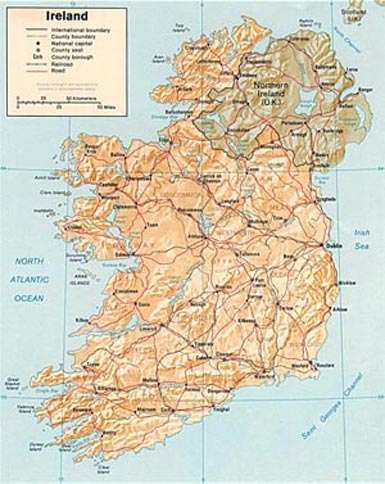
Road Map of Northern Ireland and Ireland -
Click on the map for a larger printable image
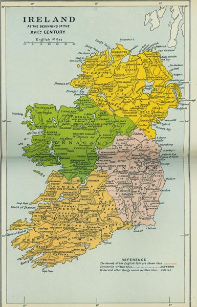
Map of Northern Ireland and Ireland - 16th Century
The image below shows Northern Ireland and the Republic of Ireland as a single country separated into four areas known as provinces at the beginning of the 16th Century. Click here or on the map for a larger printable image. The location of the origin of family surnames have also been included. Particularly useful for genealogy research or anyone wishing to see where their Irish family or surname originally came from! Some of the surnames include O' prefix, and spellings slightly differ from surnames used today.
16th Century Map of the Island of Ireland -
Click on the map for a larger printable image
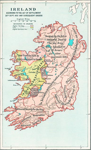
Map of Northern Ireland and Ireland - Settlement Act 1653
The map below represents how the Island of Ireland was divided according the the Act Of Settlement passed on the 26th September 1653 by the English parliament and Oliver Cromwell. Click here or on the map below for a larger printable image. Oliver Cromwell and the English parliament passed the order to force the Irish people 'To Hell or to Connaught'. The Irish people had their land taken away and were either killed or moved to the small section of Ireland located to the west of the River Shannon covering the counties of Clare, Roscommon, Galway and a large part of Mayo The seizure of the Irish land was punishment by Cromwell for the Irish rebellion of 1641, he was determined to remove land and property from the Irish people and hand it over to the English.
Image of the Island of Ireland in 1632
Click on the map for a larger printable image
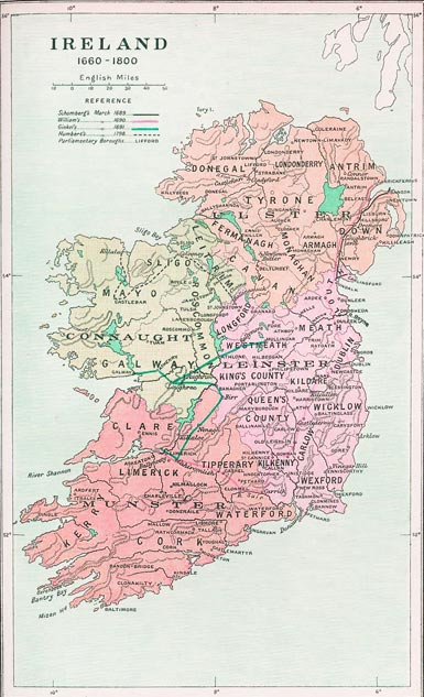
Map of Northern Ireland and Ireland - Historical Map 1660-1800
The map below depicts how the Island of Ireland looked from the years 1660 to 1800. There are several lines added to the map showing the routes of important historical events that occurred during that period. They include:
Schomberg's March - This event began in 1689 when Frederick Schomberg who was the 1st Duke of Schomberg landed at Ballyholme Bay in County Down as leader of King William's army to take part in the Williamite–Jacobite War, known in Irish as 'Cogadh an Dá Rí' which translates to 'The War of the Two Kings' and refers to the war was between Catholic King James II and Protestant King William of Orange to decide who would become King of England, Scotland and Ireland. Schomberg's campaign was a slow one, his path was blocked by Tyrconnell who was the leader of the Jacobite army (King James II). Thousands of soldiers were lost to disease and not through battle as both armies camped through harsh winter weather and lack of food.
William's March - William III of England was also known as Prince of Orange and is probably best known as 'King Billy'. Protestant William was victorious over Catholic James in the Battle of The Boyne, an iconic event in Irish history which took place on the 1st July 1690. The Battle of The Boyne is commemorated every year on the 12th July by Protestants who march to celebrate the victory of Protestant King Billy over the Catholics. The Battle of the Boyne is a hugely symbolic event in the history of Ireland and Britain and is often referred to as simply 'The Twelfth'. Even today celebrations held by the protestant Orange orders causes controversy with the Catholics.
Ginkel's March - Godard de Ginkell was the leader of the Williamite army who fought against the Jacobites (led by Marquis de St Ruth) in the Battle of Aughrim (July 1691). The Battle of Aughrim was the last and decisive battle of the Williamite War in Ireland. It was fought between the Jacobites and the forces of William III in Aughrim in County Galway. It ended the period of Jacobitism in Ireland. (Jacobitism was a political movement in United Kingdom and Ireland, their aim was to restore the James II of England who was the Stuart King to the throne of England, Scotland and Ireland.
Jacobitism took its name from Jacobus, which is the Latin form of James.)
Humberts March - This event occurred in 1798 and was part of the Irish Rebellion of 1798, an uprising against British rule in Ireland. The rebellion lasted from May to September 1798. In August 1798, about 1,000 French soldiers under General Jean Humbert landed at Kilcummin in County Mayo. Joined by up to 5,000 local rebels, they had some success against the English, at the Battle of Castlebar in County Mayo and the Battle of Collooney in County Sligo and even set up a "Republic of Connaught" for a short tine. These battles are commonly known to the people in the West of Ireland as 'Bliain na bhFrancach' which translates as "The Year of the French". The commander for the French army was Jean Humbert and the map shows the route taken by the French army.
Image of Ireland from 1660-1800
Click on the map for a larger printable image
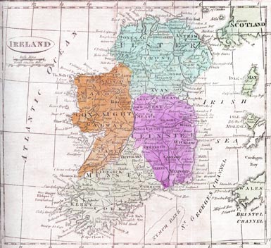
Map of Northern Ireland and Ireland - 1808
The map below shows the four provinces which make up the Island of Ireland; Ulster, Connaught, Leinster and Munster. Ulster includes the following counties: Antrim, Armagh, Cavan, Donegal, Down, Fermanagh, Londonderry, Monaghan, and Tyrone. Three of the counties in Ulster are actually part of the Republic of Ireland! The province of Connaught includes counties: Galway, Leitrim, Mayo, Roscommon and Sligo. The Leinster province includes the most counties, they are: Carlow, Dublin, Kildare, Kilkenny, Laois, Longford, Louth, Meath, Offaly, Westmeath, Wexford and Wicklow. Finally, the province of Munster includes counties: Clare, Cork, Kerry, Limerick, Tipperary and Waterford.
Image of Ireland with Provinces in 1808
Click on the map for a larger printable image